photo: Jim McGaw eastbayri.com
On Monday, March 4th, Bike Newport Executive Director, Bari Freeman, addressed the Middletown Town Council regarding the opportunity to improve road safety on East Main Road during the 2024 repaving project. She was representing the Aquidneck Island project “Ride Island” * of which Bike Newport is a lead partner, together with Grow Smart RI, Toole Design Group, and van Beuren Charitable Foundation.
The recommended paving configuration is called a road diet. The Federal Highway Administration (FHWA) defines a road diet as: converting an existing four-lane, undivided roadway segment to a three-lane segment consisting of two through lanes and a center, two-way left-turn lane.
The FHWA further states: The resulting benefits include a crash reduction of 19 to 47 percent, reduced vehicle speed differential, improved mobility and access by all road users, and integration of the roadway into surrounding uses that results in an enhanced quality of life. A key feature of a Road Diet is that it allows reclaimed space to be allocated for other uses, such as turn lanes, bus lanes, pedestrian refuge islands, bike lanes, sidewalks, bus shelters, parking or landscaping.
For these reasons, FHWA, USDOT, and RIDOT include road diets as a favored “Safety Countermeasure” to be implemented when the conditions of the road meet the standards for the design.
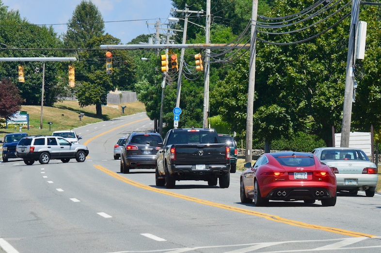
This is a discussion about road safety. A road diet is being considered because there are more than 200 vehicle crashes on East Main Road every year. Will a road diet reduce/eliminate crashes and make East Main Road a safe community road in service to road users, residents, and businesses? Will a road diet enhance life and economy? As a community we can request the information that will help us to make that determination.
In July 2023, RIDOT provided information regarding a road diet on East Main Road to the Middletown Town Administrator in the form of a memo from their consultants, VHB. The memo addressed the anticipated impact of a road diet on vehicle volume, speed, and travel times. Both the Town Administrator and Bari Freeman referred to this memo at the March 4th meeting:
- Bari shared several questions raised when Ride Island reviewed the report:
- The memo did not address the significant safety benefits which are the urgent reason for the road diet. (Note: since the meeting, RIDOT informed us that the study was not scoped to address safety benefits because those outcomes are already well known.)
- The report was based on simulation models that did not consider the impact of the traffic stopping in the left travel lane to make left turns – which is a significant contributor to disrupted traffic flow, and a primary cause of rear end and side crashes.
- These omissions raise questions about the accuracy of the comparison between existing conditions and the built conditions (after a road diet) – i.e. the difference in travel time will be significantly lessened when the existing conditions are corrected.
- Town Administrator, Shawn Brown, expressed concerns about community response to the increased travel time predicted in the memo. He recommended that the Council request additional information from RIDOT including: existing conditions, predictions of what to expect on both East Main Road and West Main Road, and possible impact on local businesses should East Main Road implement a road diet.
The Middletown Town Councilors likewise raised questions which they would like addressed. Ride Island and RIDOT have since met to discuss gathering information in response to those questions for consideration by the Town Council and the community, including:
- Crash data for East Main Road
- Traffic simulations with and without a road diet
- What the road diet would look like on East Main Road – in the travel lanes and at signalized intersections
- Where the road diet can be implemented, including potentially extending into Portsmouth
- Predictions related to changes in traffic volume and flow for East Main Road
- Expected implications to traffic volume on West Main Road
- Expected implications for local businesses and their customers
The researchers and engineers affiliated with Ride Island will additionally provide before/after studies from communities where road diets have been implemented.
Why is a Road Diet being recommended for East Main Road?
To reduce the frequency of crashes and make it a safer and better experience for everyone:
- Slower is Safer: The FHWA Safe System Approach focuses on road design and road speed. Road diets result in consistently slower and safer speeds. Read more HERE.
- Isolate Left Turns: East Main Road experiences high crash frequency in large part because of the need to stop in the left travel lane to make a left turn. Drivers behind a turning car have to wait, or may opt to change lanes to avoid the delay. The driver who is turning feels pressured to make the turn, often before there is enough space to do so safely. These maneuvers are primary causes of driver stress and crashes on East Main Road.
- More on Left Turns: Drivers turning left can safely wait in the center turning lane until they can complete their turn. And drivers in the travel lane have no need to change lanes to avoid a stopped car.
- Safer entry: Drivers entering the road and turning left from side roads need only cross one lane to get to the turning lane where they can navigate into the travel lane going in their direction. Drivers entering the road and turning right from side roads will negotiate with cars at a slower speed.
- Better for business: The center turning lane makes it easier for people to turn into and out of businesses that are not located at signaled intersections.
- Shoulders: The reclaimed road space provides shoulders on both sides of the road. The shoulders support urgent safety improvements such as pedestrian refuge islands, bike lanes, sidewalks, and bus stops. Road diets can improve mobility and access for all road users.
- Timing: Implementing a road diet at the time of the resurfacing project means it can take place with no additional changes to the roadbed and at no additional cost.
Data collection is underway in preparation for a follow-up community meeting. Vehicle counts, crash data, traffic simulations, case studies, and plan previews will help us to understand the expectations and implications. We look forward to a well-informed community discussion with the safest outcomes as our collective goal.
* “Ride Island” refers to Aquidneck Island and is a project designed to identify and guide implementation of an islandwide bike network with consideration of pedestrian and transit accommodation as well. The project makes progress based on existing studies and in collaboration with leaders and stakeholders in all three island municipalities and the Navy. Learn more at www.rideisland.org.

 Bike Newport